Is a Hurricane Forming in the Atlantic? Your Mid-August Tropics Watch and Prep Checklist
You heard a hurricane might be forming. Here is what the National Hurricane Center is actually tracking as of Friday morning, August 14, 2026, what the rest of the season is expected to look like, and the two-week head start you can take right now.
TL;DR:
- No hurricane or tropical storm is active in the Atlantic right now. Tropical Storm Cristobal formed on August 12 far out at sea, never threatened land, and is already gone.
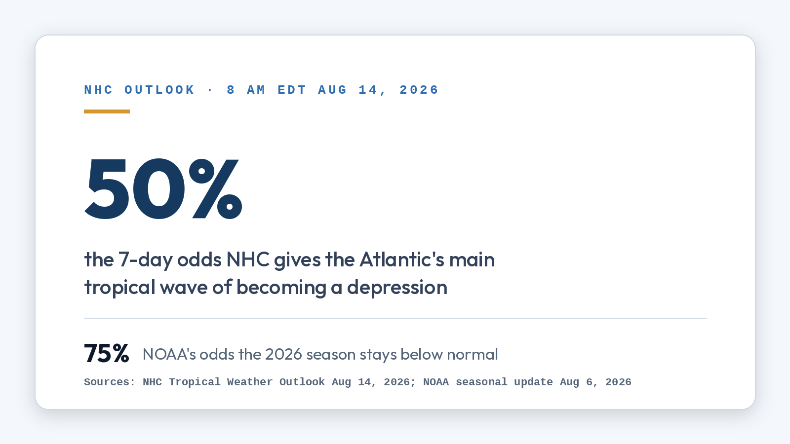
- The system worth watching is a tropical wave the NHC gives a 50% chance of becoming a tropical depression within 7 days as it moves toward the northeastern Caribbean.
- NOAA's updated seasonal forecast calls for a below-normal season: 7 to 13 named storms, 2 to 6 hurricanes. A quiet forecast is not a guarantee; it only takes one landfall.
- The statistical peak of the season is September 10. Use the quiet window now to document your home, read your policy, and know your deadlines.
Storm information in this article is current as of the National Hurricane Center's 8 AM EDT outlook on Friday, August 14, 2026. Forecasts change quickly; for live advisories, always check the National Hurricane Center directly.
Is a hurricane forming in the Atlantic right now?
Not at this moment. As of Friday morning there are no active hurricanes or tropical storms anywhere in the Atlantic basin. What you likely heard about is one of two things.
The first is Tropical Storm Cristobal, which the NHC named on August 12 in the open Atlantic, roughly between Bermuda and the Azores. It was a short-lived "fish storm" that never approached the United States, and by Friday morning it was off the NHC's active map entirely.
The second, and the one that matters for the Southeast coast, is a tropical wave in the central Atlantic that the NHC's Tropical Weather Outlook flags with a 30% chance of development over the next 48 hours and a 50% chance over the next 7 days. Conditions ahead of it are described as generally conducive for gradual development, and a tropical depression could form this weekend or early next week as it tracks westward. On its current schedule it would be in the vicinity of the northeastern Caribbean islands around Sunday or Monday. A second, weaker wave near the Lesser Antilles is running into hostile upper-level winds and dry air, and its odds are fading at 20%.
If either system organizes into a named storm, it will be called Dolly, the next name on this year's Atlantic list.
The honest answer for Florida and South Carolina homeowners: nothing is aimed at us today, and it is far too early to say whether the watched wave ever will be. That is not a reason to tune out. It is a rare, valuable thing: advance notice with time to act.
What does the rest of the 2026 season look like?
NOAA's August 6 seasonal update maintained its below-normal outlook: a 75% chance the season finishes below normal, with 7 to 13 named storms, 2 to 6 hurricanes, and 0 to 2 major hurricanes expected for the full June 1 to November 30 season. The main brake on the Atlantic this year is El Niño, which increases the wind shear that tears developing storms apart. So far the season has produced three named storms, Arthur, Bertha, and Cristobal, and no hurricanes.
| 2026 outlook (NOAA, Aug 6 update) | Forecast range | Average season (1991-2020) |
|---|---|---|
| Named storms | 7 to 13 | 14 |
| Hurricanes | 2 to 6 | 7 |
| Major hurricanes (Cat 3+) | 0 to 2 | 3 |
| Chance season stays below normal | 75% | n/a |
Two caveats belong next to that table. First, the climatological peak of the season is September 10, and the heart of the season, mid-August through October, is only now beginning. Most of whatever 2026 produces is still ahead of us, which is exactly why the tropics are stirring this week.
Second, seasonal totals do not protect any individual address. The textbook example is 1992: one of the quietest seasons on record, and it produced Hurricane Andrew. A below-normal year with one bad landfall is a catastrophic year for the neighborhoods in its path. Forecasters repeat this every year because it keeps being true: it only takes one.
What should Florida and South Carolina homeowners do this week?
A watched wave ten days from any possible impact is not a reason to board windows. It is the ideal moment for the quiet work that decides how insurance claims go later. Four things, none of which cost money:
1. Document your home while it is undamaged. Walk every room with your phone recording video, narrate as you go, and open closets and cabinets. Photograph the roof from the ground on all four sides, the fence, the pool cage or enclosure if you have one, and anything of value in the garage. Store it in the cloud, not only on the phone. When an adjuster later questions whether damage is new or "pre-existing wear," date-stamped footage from August answers the question in your favor.

2. Read the two numbers in your policy that decide a hurricane claim. The first is your hurricane deductible, which in most Florida and coastal South Carolina policies is 2% to 10% of your dwelling coverage rather than a flat dollar amount. On a $400,000 dwelling limit, a 5% hurricane deductible means the first $20,000 comes out of your pocket, and knowing that now beats discovering it in a claim worksheet. The second is the water language: standard homeowners policies cover wind and wind-driven rain damage but exclude storm surge and rising floodwater, which are the job of a separate flood policy through the National Flood Insurance Program or a private carrier. Note that new flood policies typically carry a 30-day waiting period, so this is a decision for now, not for cone day.
3. Do the small maintenance that prevents coverage fights. Clear gutters and drains, trim limbs hanging over the roof, and secure or plan storage for loose yard items. Insurers scrutinize whether damage resulted from the storm or from deferred maintenance; removing the ambiguity now removes the argument later.
4. Know your deadlines before you need them. Claim reporting and lawsuit deadlines are set by state law and by your policy, and they differ between Florida and South Carolina. We keep a plain-English rundown for each state: the Florida claim deadlines guide and the South Carolina property insurance claims guide.
Pro Tip: Storm prep lists focus on water bottles and batteries, and those matter for your family's safety. For your financial recovery, the highest-value item is the one nobody sells: proof of your home's condition before the storm. Fifteen minutes of narrated video this weekend can be worth more in a disputed claim than hours of arguing from memory afterward.
What if a storm does hit and you have damage?
If the Atlantic's watched wave, or any system after it, ever puts Florida or South Carolina inside the cone, the claim playbook starts the moment it is safe to be outside: photograph everything before touching anything, make only the temporary repairs needed to prevent further damage (tarp the roof, dry the water), keep every receipt, and report the claim promptly in writing. Our hurricane damage claims page walks through the full sequence, including the mistakes that shrink settlements, like accepting a quick first offer before hidden damage is found or giving a recorded statement without preparation.
The one thing not to do is assume the insurer's first number is the final number. Hurricane claims involve percentage deductibles, wind-versus-water disputes, and damage that surfaces weeks later, and initial estimates routinely miss real scope. That is the gap a licensed public adjuster exists to close.
Key Takeaways
| Point | Details |
|---|---|
| Today's threat level | No active Atlantic hurricanes or tropical storms as of August 14, 2026; nothing currently threatens FL or SC |
| The system to watch | A central Atlantic tropical wave: 50% odds of becoming a depression within 7 days, near the northeastern Caribbean by Sunday or Monday |
| Season outlook | NOAA calls for below normal: 7-13 named storms, 2-6 hurricanes, with El Niño suppressing activity |
| The catch | The season's peak is September 10 and one landfall is all it takes; 1992 was a quiet year that produced Andrew |
| This week's move | Document your undamaged home, check your hurricane deductible and flood coverage, handle small maintenance, learn your state's deadlines |
| If damage ever comes | Photograph first, protect the property, keep receipts, report in writing, and get the estimate independently checked |
What we see in the field
Every storm season follows the same arc in our files. The claims that settle well are the ones where the homeowner can show what the property looked like before the wind arrived. The claims that turn into fights are the ones where the only "before" picture is a real estate listing photo from six years ago, and the carrier's adjuster writes off shingle damage as wear and tear because nothing proves otherwise.
We also see the deductible surprise over and over. Families budget their recovery around a $2,500 deductible from the declarations page and learn mid-claim that the hurricane deductible is a percentage, and five figures. Nobody reads that clause for the first time calmly; read it this week instead.
And after every named storm, we meet homeowners whose worst damage came from water rising into the house, only to learn their homeowners policy never covered flood at all. The 30-day flood policy waiting period means that decision cannot be made when a cone appears. The quiet stretch of a below-normal August is precisely when it can.
- The Vanguard field team
How Vanguard Claims Solutions helps
If a storm does damage your home this season, you do not have to take the insurance company's word for what the claim is worth. Vanguard Claims Solutions documents the full scope of storm damage, prepares and files the claim, and negotiates directly with the carrier on your behalf. The inspection is free, there are no upfront fees, we work on contingency, and the fee for your claim is set out in the written contingency agreement before you sign. Licensed in Florida and South Carolina, led by public adjuster Andrew Pichardo (FL #W493213, SC #18873906). Call (305) 336-3302 or request your free claim review.
FAQ
Is a hurricane coming to Florida or South Carolina right now?
No. As of the National Hurricane Center's August 14, 2026 outlook there are no active hurricanes or tropical storms in the Atlantic, and the tropical wave being watched is more than a week away from any possible U.S. impact, if it develops at all. Check the NHC for current advisories, since this can change within days.
What is the difference between a tropical wave, a depression, a tropical storm, and a hurricane?
A tropical wave is a disorganized area of showers and thunderstorms. If it develops a closed circulation it becomes a tropical depression, at sustained winds of 39 mph it becomes a named tropical storm, and at 74 mph it becomes a hurricane. The Atlantic wave in this update is still at the first stage.
Does NOAA's below-normal forecast mean we are safe this year?
No. Seasonal forecasts predict basin-wide activity, not where any single storm goes. The often-cited example is 1992, a very quiet season that produced Hurricane Andrew. Preparation and documentation matter every year regardless of the seasonal numbers.
Does homeowners insurance cover hurricane damage?
Standard policies generally cover wind and wind-driven rain damage, subject to a separate hurricane deductible that is usually a percentage of your dwelling coverage. Storm surge and rising floodwater are excluded and require separate flood insurance, which typically has a 30-day waiting period before it takes effect. Our hurricane damage claims guide covers the details.
When is the peak of hurricane season?
The Atlantic season runs June 1 through November 30, and activity climbs sharply from mid-August, peaks around September 10, and stays elevated through October. Most of the season's strongest storms historically form in that window, which is why forecasters treat mid-August as the start of the serious stretch.
Recommended
Dealing with this claim right now?
A licensed adjuster will review your loss and policy for free, with no obligation.